Long before anyone thought of walking for pleasure, people crossed Dartmoor because they had to. Monks travelled between abbeys, tenants carried tithes, and funeral parties brought their dead to consecrated ground. The moor was not scenery. It was the obstacle between one place and another.
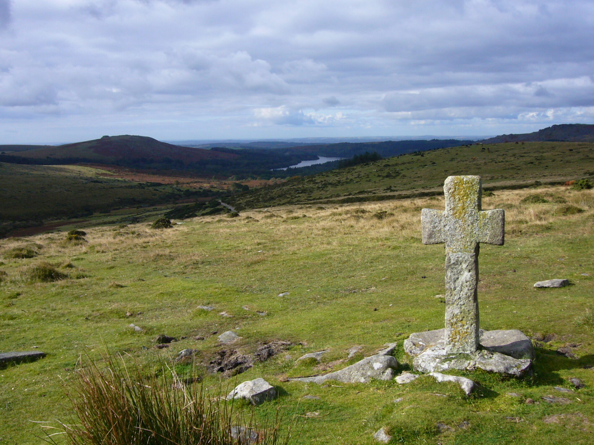
What those travellers left behind is remarkable, and most visitors walk past it without noticing. Scattered across the high moor stand granite crosses, some of them more than 700 years old, set up as waymarks so that nobody would lose the track in mist. They are still there. You can still follow them.
This is a guide to Dartmoor’s pilgrim paths: the Abbot’s Way and the crosses that mark it, the long argument about where the route actually ran, the modern pilgrimage routes crossing Devon today, and how to walk any of them safely.
Why the moor is covered in crosses
Medieval Dartmoor was ringed by religious houses. Tavistock Abbey was the largest and wealthiest, with Buckfast Abbey a close second, and a further community of monks at Plymstock. Buckfast itself was founded in 1018, when King Canute established a Benedictine house there.
These abbeys were not isolated. They held manors, collected tithes, ran markets and exercised real political power, which meant a steady traffic of monks and lay brothers moving between them. The direct line from Buckfast to Tavistock runs straight across the highest and emptiest part of the moor, over blanket bog, past Fox Tor mire, through country where a mist can close in within minutes.
So the abbeys marked the way. Granite crosses were raised at intervals along the track, each one visible from the last, so that a traveller could move from waymark to waymark without a map or a path. The historian Eric Hemery, whose Walking Dartmoor’s Ancient Tracks remains the standard work on the subject, pointed out that no written record of these routes survives. What survives instead are the crosses themselves.
None of this was unique to Devon. Waymarking the road between religious houses was a habit across medieval Europe, and the largest surviving network of those roads still runs from central France down to the Pyrenees and on into Spain, towards the shrine at Santiago de Compostela. Those routes never fell out of use, and walkers still cross them in stages over several weeks. Agencies that organise walking the Way of St James will book each night ahead for you and carry your luggage between stops, which is how most people tackle them now. It is worth knowing that the crosses on Dartmoor belong to the same tradition, at the far western edge of it.
The Abbot’s Way: Buckfast to Tavistock
The Abbot’s Way is the best known of Dartmoor’s monastic crossings, running roughly 20 miles between the two abbeys. Parts of it date back to the 11th century, and it is arguably the oldest trans-moorland route on Dartmoor.
The eastern approach leaves Buckfast and climbs through Hockmoor Head towards Holne Moor, where the enclosed farmland gives out and the open moor begins. From there the route crosses the watershed of the South Moor before dropping towards Walkhampton and finally Tavistock, where the abbey is now a scatter of ruins and reused stone in the middle of a market town.
A word of caution about the name. Hemery was blunt about it, arguing that Abbot’s Way was a misleading title and that much of the traffic along the track was commercial rather than religious, with wool jobbers and packhorse trains using the same line. The truth is probably both. A route that serves an abbey serves whatever the abbey trades in.
The crosses along the way
The crosses are the reason to walk this route rather than any other on the moor. There are eighteen surviving examples along the northern line of the crossing, and they have had rough lives. Some were broken, others went missing entirely, and a number were later found built into walls or reused as gateposts before Dartmoor antiquarians tracked them down and re-erected them.
Hawsons Cross
A Latin cross standing on a small triangular island at the Stumpy Oak crossroads, on the road between Buckfast and Holne. It was found in a nearby wall, given a new shaft and re-erected in the middle of the last century. Hemery treated it as the first waypoint on the eastern section.
Horn’s Cross
Further west on Holne Moor, marking the point where the route commits to the high ground. From here on, there is no shelter and no road.
Childe’s Tomb
Not a cross in origin but a kistvaen with a cross set on it, and the most storied landmark on the whole crossing. The legend has a hunter named Childe caught out by a blizzard, killing his horse and sheltering inside the carcass, leaving a message that whoever buried him would inherit his lands. The monks of Tavistock got there first. Whether any of it happened is another matter, but the tomb sits in the open near Fox Tor mire and it is a bleak and memorable place to stand.
Mount Misery
The name tells you what the surrounding country is like. The cross stands above the wilderness of Fox Tor mire, and in poor visibility it is exactly the kind of marker the monks intended.
Warren’s Cross
Worth mentioning because there is no cross here at all. Hemery recorded his surprise at its absence and suggested that one of the two crosses now standing at Buckfast Abbey may originally have come from this spot. Today it is a quiet crossroads on the modern Dartmoor Way.
The route that may have been wrong for a century
Here is the part that surprises people. The Abbot’s Way printed on Ordnance Survey maps may not be the Abbot’s Way at all.
The line first appeared on a map in 1886 and was challenged almost immediately by historians and Dartmoor writers. The objection is simple and hard to argue with: along the eastern section of the mapped route there are no crosses. A few miles to the north, however, there is a continuous line of them, running from Holne Moor across the wilderness towards Tavistock.
The author Nick Pannell walked and researched the northern line for his book The Real Abbot’s Way, and Historic England has since accepted that the mapped route is not the historical one, noting that the crosses appear on the map in the italic script reserved for historic features while the words Abbot’s Way do not.
For a walker, this is more than a footnote. It means the version of the crossing with the crosses on it, the version worth walking, is not the one the map sends you along. If you want the crosses, take the northern line.
Walking the Abbot’s Way today
Distance: around 20 miles (32 km) between the abbeys
Difficulty: hard
Time: a long single day, or two days with a wild camp
This is not a waymarked trail in the modern sense. There are no signposts, no painted markers and, on the northern line, often no path underfoot at all. What you have are the crosses, which is precisely what a medieval traveller had.
Most walkers do it in one long day, setting off early from Buckfast and arranging a lift or a bus at the Tavistock end. Splitting it over two days means either a wild camp on the moor or dropping off the route to Princetown for the night.
A few things to sort out before you go.
Navigation. Carry the OS map and a compass and know how to use them, and treat GPS as a backup rather than a plan. Mist on the South Moor arrives quickly and reduces visibility to a few metres.
Bogs. Fox Tor mire and the surrounding blanket bog are not decorative. Learn to read the ground, keep to firmer tussocky sections, and do not attempt to cross wet ground in poor light.
Firing ranges. The three live firing ranges, Okehampton, Merrivale and Willsworthy, lie on north Dartmoor, so a straight crossing between the abbeys stays clear of them. If you extend the walk north, check the firing timetable first and never enter a range when the red flags are flying by day or the red lamps at night.
Water and food. There is nothing between the two ends. Carry everything, including more water than you expect to drink.
If a full crossing sounds like too much, we would point you towards the eastern crosses around Holne Moor, which give you the same atmosphere over a much shorter day, or to the gentler options among the best walks on Dartmoor.
Other pilgrim routes across Dartmoor and Devon
The monastic crossings are not the only pilgrim paths in the area. The Diocese of Exeter has created a set of modern routes under the name Devon Pilgrim, designed to be walked by anyone, whatever their beliefs.
The Archangel’s Way is the one that matters most to Dartmoor. It runs across the north of the moor between two churches dedicated to St Michael, from the extraordinary St Michael de Rupe perched on the volcanic plug at Brentor to St Michael the Archangel at Chagford. It is the route that gives you the moor at its most exposed.
The Sacred Waters Way follows the river Dart from its source on the high moor down to the sea, which keeps it tied to the moor even once it leaves the national park behind.
The St Boniface Way covers 14 miles from Crediton, birthplace of Devon’s patron saint, to Exeter Cathedral. The Eden Way explores the Teign valley where the moor meets farmland, and further routes run to Lundy and along the Little Dart.
Several of these come with downloadable guides and a pilgrim passport to be stamped at churches along the way, which is a direct borrowing from the continental tradition.
Planning a pilgrimage walk on Dartmoor
When to go
May to September gives you the longest days and the best chance of seeing the crosses at any distance. September is arguably the best of the four, with firmer ground after the summer and fewer people about. Winter walking on the high moor is for the experienced only, with short daylight and serious exposure.
What to take
Boots that cope with wet ground, full waterproofs whatever the forecast says, map and compass, a headtorch, and enough food and water for the whole crossing. Mobile coverage on the high moor ranges from patchy to non-existent.
Where to stay
Buckfastleigh and Ashburton work well for the eastern end, Tavistock for the western, and Princetown sits in the middle if you want to split the walk. The Dartmoor Commons are the only place in England and Wales where the public has a legal right to wild camp, confirmed by the Supreme Court, provided you follow the code of conduct and leave no trace. Check which areas are covered before you pitch.
Walking it as a pilgrimage
You do not need to be religious to walk these routes, and most people who do are not. What the pilgrim framing changes is the pace. Rather than covering ground as fast as possible, you stop at each cross, you notice how the country changes between them, and you finish somewhere that meant something to whoever built the path.
Dartmoor pilgrim routes FAQ
What is the Abbot’s Way on Dartmoor?
The Abbot’s Way is an ancient crossing of roughly 20 miles between Buckfast Abbey and Tavistock Abbey, used from at least the 11th century by monks travelling between the two houses. It is marked by a line of granite crosses rather than by signposts.
How many crosses are there on the Abbot’s Way?
Eighteen crosses survive along the northern line of the route, several of them more than 700 years old. A number were lost or reused as building material over the centuries before being recovered and re-erected.
Is the Abbot’s Way marked correctly on OS maps?
Probably not. The mapped line, first printed in 1886, has no crosses along its eastern section, while a route a few miles north follows a continuous line of them. Historic England has accepted that the mapped version is not the historical route.
Can beginners walk the Abbot’s Way?
It is not a beginner’s route. There is no waymarking, often no path, no shelter and no water along the crossing, and navigation over blanket bog in poor visibility needs real experience. Shorter walks around the eastern crosses are a better introduction.
Are there other pilgrim routes in Devon?
Yes. The Diocese of Exeter’s Devon Pilgrim project has created six routes, including the Archangel’s Way across northern Dartmoor, the Sacred Waters Way along the river Dart, and the St Boniface Way from Crediton to Exeter Cathedral.
Do you need to be religious to walk a pilgrim route?
No. Modern pilgrimage routes are walked by people of all beliefs and none, and the organisations behind them present them as open to everyone. Most walkers come for the landscape, the history and the slower pace rather than for worship.